Topo Surveyor understands that booking a topographical survey can feel overwhelming if you've never needed one before. Whether you're a property buyer, developer planning a construction project, or architect preparing a planning application, understanding what topographical surveys offer will help you make informed decisions. This comprehensive guide explains everything about topographic land surveys, from basic concepts to practical applications.
What is a Topographical Survey?
A topographical survey is a detailed three-dimensional map of a plot of land that captures both natural and man-made features. Unlike simple property plans, a topographic survey records accurate measurements of terrain elevation using contour lines, identifies boundary locations, documents drainage systems, and maps all significant land features.
When carrying out topographical surveys, our land surveyor team uses highly specialised survey equipment including total station instruments, GPS technology, and laser scanning. This technology captures millions of measurement points to create precise representations of your site. The results of a topographical survey provide the foundational data that architects, engineers, and planners need to design successful developments.
Natural Topographic Features Captured
Natural features are essential elements that a topographical survey could document:
- Terrain and Elevation - Contour lines show height changes across the area of land, revealing slopes, valleys, and plateaus that affect construction feasibility and drainage patterns.
- Vegetation - Trees, hedges, and significant vegetation are recorded with species identification and measurements, crucial for tree surveys and environmental impact assessment.
- Water Features - Rivers, streams, ponds, and ditches are mapped with flow directions and seasonal variations affecting drainage planning.
- Rock Outcrops - Exposed bedrock and geological features that may impact excavation costs and foundation design.
- Natural Boundaries - Hedgerows, tree lines, and topographic features that historically defined property boundaries.
Man-Made Features and Structures
A comprehensive topographic survey also captures man-made elements:
- Buildings and Structures - All buildings, outbuildings, walls, and permanent structures with precise dimensions and heights.
- Hard Surfaces - Roads, driveways, paths, patios, and other paved or concrete surfaces affecting site access and drainage.
- Boundary Features - Fences, walls, hedges, and markers defining property lines for land registry purposes.
- Utilities - Visible utility infrastructure including manholes, inspection chambers, telegraph poles, and lamp posts.
- Site Furniture - Gates, bollards, signs, benches, and other fixed features relevant to development planning.
When Do You Need a Topographical Survey?
Getting correct information early through professional topographical surveys can save considerable time and reduce cost throughout your project. Here are common scenarios where you need a topographical survey:
Planning Applications
Most local planning authorities require a topographical land survey as part of planning applications. The survey data demonstrates how your proposed development fits the existing site context, addresses drainage concerns, and considers environmental impact. Planning officers use topographic maps with contour lines to assess whether proposals are appropriate for the terrain and neighborhood.
For residential extensions, new builds, or change of use applications, architects need detailed survey data to create accurate site plans. The level of detail in your topographical survey directly affects the quality of architectural drawings and the likelihood of planning approval. Our survey experts understand what local authorities require and ensure the survey report meets all specifications.
Construction Projects
Before any construction project begins, a topographic survey provides essential baseline data. Engineers use survey data to design grading plans, calculate earthwork quantities, plan drainage systems, and position structures optimally. Without accurate measurements, construction costs can escalate due to unexpected site conditions.
The topographical survey helps identify potential challenges early. Steep slopes might require retaining walls. Poor drainage might need additional infrastructure. Underground services might constrain building placement. Addressing these issues during design—when you have the help of topographical survey data—prevents costly surprises during construction.
Property Purchase Due Diligence
Property buyers increasingly commission topographical surveys as part of due diligence, especially for land purchases or properties with development potential. The survey reveals exactly what you're buying: actual land area, boundaries, easements, access issues, drainage problems, and development constraints.
For building plots or property or land with planning permission, a topographic survey verifies that the site matches advertised descriptions and legal documents. This information can inform purchase negotiations, help avoid future boundary disputes, and provide peace of mind that you understand your land completely.
Infrastructure Development
Large-scale infrastructure projects like roads, utilities, telecommunications, or renewable energy installations require extensive topographic land surveys. Our survey company provides detailed terrain surveys covering large areas, capturing natural features, existing infrastructure, access routes, and environmental sensitivities.
These surveys often integrate GPS technology with traditional surveying methods to maintain accuracy across vast distances. The CAD drawing delivery includes multiple layers of information that engineers can use for different project phases, from initial feasibility through detailed design to construction and monitoring.
Landscape Design and Drainage
Landscape architects rely on topographical surveys to design gardens, parks, sports facilities, and outdoor spaces. Contour information reveals how water flows naturally across the site, informing drainage solutions, irrigation planning, and planting strategies. The survey data helps create designs that work with the terrain rather than fighting against it.
For drainage projects specifically, a topographical survey is essential. Surface water flow follows terrain, and accurate contour mapping predicts where water accumulates, which areas flood, and how proposed drainage systems should be designed. Our surveyor will conduct detailed site visits to capture all relevant information for drainage assessment.
The Topographical Survey Process
Understanding the survey process helps you prepare and know what to expect when booking a topographical survey:
Step 1: Initial Consultation
When you get in touch with Topo Surveyor, we discuss your specific needs: intended use for the survey, required level of detail, target CAD formats, and project timeline. We'll explain what type of survey best suits your requirements and provide a transparent survey cost estimate. This conversation ensures we capture exactly what you need without unnecessary additional work.
Step 2: Desktop Research
Before arriving on site, our land surveyors conduct background research. We examine Ordnance Survey maps, check for utility records, review any previous surveys, and identify potential access issues or health and safety concerns. This preparation ensures efficient fieldwork and helps identify areas requiring special attention.
Step 3: Site Survey
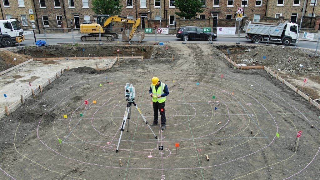
Our surveyor will conduct a thorough site visit using highly specialised survey equipment. The total station establishes control points and captures precise measurements. GPS technology provides accurate positioning referenced to Ordnance Survey coordinates. Laser scanning might be used for complex sites or where rapid data capture is beneficial.
During carrying out topographical surveys, we record all relevant features systematically. The survey duration depends on the area of land and complexity—a typical residential plot takes 4-8 hours, while larger sites might require multiple days. We work methodically to ensure nothing is missed and all measurements meet professional accuracy standards.
Step 4: Data Processing
Raw survey data is processed using specialist software. We create the topographic map, calculate contour lines, verify measurements, and compile information into structured datasets. Quality checks ensure accuracy before moving to CAD drawing production. This processing phase typically takes 2-3 days depending on project complexity.
Step 5: CAD Drawing Production
The survey data is transformed into professional CAD drawings showing all features clearly. We produce scaled survey drawings at appropriate scales (commonly 1:200, 1:500, or 1:1250 depending on site size). Multiple file formats ensure compatibility with your architect or engineer's software. Drawings include legends, north points, scale bars, and coordinate grids.
Step 6: Survey Report Delivery
The complete survey report includes CAD drawings in multiple formats, survey notes explaining methodology and limitations, accuracy statements, and any observations about site conditions. We provide both digital files and printed plans if required. The results of the survey are delivered via secure file transfer or courier depending on urgency.
Step 7: Post-Survey Support
Our service doesn't end with delivery. We provide ongoing support to help interpret survey data, answer questions from architects or planners, and clarify any aspects of the topographical survey. If additional information is needed, our surveyor will conduct follow-up visits to supplement the original survey.
Survey Equipment and Technology
Modern topographical surveyors use advanced technology to ensure accurate measurements and efficient data capture:
Total Station Instruments
The total station remains the backbone of precision surveying. These instruments measure horizontal and vertical angles plus distances with millimeter accuracy. Our survey experts use Leica, Trimble, and Topcon total stations offering reflectorless measurement up to 1000 meters, on-board data processing, and wireless connectivity.
When carrying out surveys, we establish control networks using total station measurements. These provide the framework that all other measurements reference, ensuring consistent accuracy throughout the topographic land survey. The technology allows us to work efficiently even in challenging conditions with limited visibility or difficult terrain.
GPS and GNSS Technology
Global Navigation Satellite System (GNSS) technology—commonly called GPS—provides rapid positioning referenced to national coordinate systems. For large area surveys or sites requiring Ordnance Survey coordinate referencing, GPS technology offers unmatched efficiency.
We use real-time kinematic (RTK) GPS achieving centimeter-level accuracy. Base stations or network corrections ensure measurements meet survey standards. This technology excels for terrain surveys, boundary surveys covering extensive areas, and utility surveys where traditional methods prove time-consuming.
3D Laser Scanning
Laser scanners capture millions of measurement points rapidly, creating detailed point clouds representing complex surfaces. This technology excels for measured building surveys, heritage documentation, and sites with intricate topographic features. The data provides an archival record capturing every detail visible at the time of survey.
While laser scanning generates massive datasets, the level of detail benefits architects planning complex developments or engineers analyzing existing structures. We process point clouds into usable CAD drawings while retaining the raw data for future reference if additional information is needed.
Unmanned Aerial Vehicles (Drones)
Drone photogrammetry complements traditional surveying methods for large sites, difficult terrain, or stockpile measurement. High-resolution imagery processed through specialized software generates accurate topographic maps and 3D models. This approach provides rapid coverage and unique perspectives valuable for construction project monitoring.
Our drone surveys meet Civil Aviation Authority regulations and insurance requirements. Combined with ground control surveys using GPS and total station equipment, drone data achieves survey-grade accuracy suitable for planning applications and engineering design.
Understanding Survey Costs
The survey cost varies based on several factors. Understanding these helps you budget appropriately and evaluate quotes:
Site Size and Complexity
The area of land directly affects cost. A small residential plot (200-400 square meters) might cost £400-£800. Medium sites (1000-2000 square meters) typically range from £800-£1,500. Large sites exceeding 5000 square meters require custom quotes based on complexity.
Site complexity matters as much as size. Dense vegetation, steep terrain, restricted access, or numerous small features increase survey time. An open field surveys quickly compared to woodland with mature trees requiring individual mapping. Underground utility surveys add complexity requiring specialized detection equipment.
Level of Detail Required
Different projects need different detail levels. A basic topographical survey for outline planning might capture features larger than 100mm with contours at 1-meter intervals. Detailed surveys for engineering design might capture features down to 10mm with 0.1-meter contour intervals. This increased precision requires more time and affects the survey cost.
Tree surveys add costs when full arboricultural assessment is needed beyond simple tree location. Measured building surveys requiring internal access and detailed architectural features cost more than external topographic surveys. Underground utility surveys using ground-penetrating radar and electromagnetic detection represent additional specialized work.
Survey Format and Deliverables
Standard CAD drawings in DWG and PDF formats are included in basic pricing. Additional formats, 3D models, Building Information Modeling (BIM) integration, or customized presentations may incur extra charges. Rush delivery also affects costs when surveys must be completed within tight timeframes.
Value of Professional Surveys
While survey costs represent an upfront investment, the value far exceeds the price. Poor survey data leads to design revisions, planning rejections, construction delays, and legal disputes—all costing multiples of the original survey cost. Getting correct information early through professional land surveying services protects against these expensive problems.
Our survey company provides transparent quotes explaining what's included, what might incur additional charges, and how the survey meets your specific requirements. We believe informed clients make better decisions, and we're always happy to discuss how to optimize the survey to meet your needs within budget constraints.
Choosing the Right Surveyor
Not all survey companies deliver equal quality or service. When you need a survey, consider these factors:
Professional Accreditation
Ensure your land surveyor holds recognized professional qualifications. Our topographical surveyors are accredited under CIOB (Chartered Institute of Building), RICS (Royal Institution of Chartered Surveyors), and RPSA (Recognised Professional Surveyor Accreditation). These bodies maintain professional standards and provide recourse if service falls short.
Insurance and Liability
Professional indemnity insurance protects you if survey errors cause financial loss. Ask about insurance coverage before commissioning work. Reputable survey companies maintain substantial coverage reflecting the financial consequences that survey mistakes can cause.
Equipment and Technology
Modern survey equipment ensures accurate measurements and efficient service. Ask what highly specialised survey equipment providers use. Latest technology doesn't guarantee quality, but outdated methods may lack the precision or efficiency that current projects require.
Local Knowledge
Survey companies operating surveys across the UK offer convenience and may understand local planning requirements, coordinate systems, and site conditions. Local knowledge helps anticipate challenges and ensures survey data meets regional authority expectations.
Communication and Service
Responsive communication matters. Can you easily get in touch with questions? Do they explain technical aspects clearly? Will they support you after delivery if architects or planners need clarification? Good survey companies view projects as relationships, not transactions.
Conclusion: The Foundation of Successful Development
Topographical surveys provide the essential data foundation for property development, construction projects, and land management. Whether you're planning extensions, seeking planning permission, purchasing land, or managing infrastructure, accurate survey data from professional topographical surveyors ensures informed decision-making.
At Topo Surveyor, we combine advanced technology, professional expertise, and personalized service to deliver survey reports that exceed expectations. Our land surveyor team understands that every topographic land survey supports important decisions affecting significant investments. We take that responsibility seriously, delivering the accuracy, detail, and support our clients need.
If you need a topographical survey, get in touch with our survey experts today. We'll discuss your requirements, explain the survey process, and provide a transparent quote for professional land surveying services tailored to your specific needs. With Topo Surveyor, you'll receive the accurate measurements and detailed survey data that successful projects demand.
Ready to Book Your Topographical Survey?
Our accredited surveyors deliver professional land survey services across the UK. Contact us today for a free, no-obligation quote and discover how our survey expertise can support your project.
Ready to Get Your Topographical Survey?
Our expert surveyors deliver accurate topographical surveys across the UK using the latest technology. Whether you need a survey for planning applications, construction projects, or property due diligence, we provide comprehensive survey data tailored to your needs.
Learn more about our professional topographical survey services →