Property boundary disputes are among the most stressful situations homeowners face. Whether it's a disagreement with neighbors about fence positions, uncertainty over land extent when purchasing property, or confusion about rights and responsibilities, boundary conflicts create anxiety and can escalate into expensive legal battles. Topo Surveyor has helped hundreds of property owners across the UK resolve boundary questions through professional boundary surveys that provide definitive, legally-sound answers.
This comprehensive guide explains how boundary surveys work, when you need one, and how professional land surveyor expertise can protect your property rights while maintaining good neighbor relations.
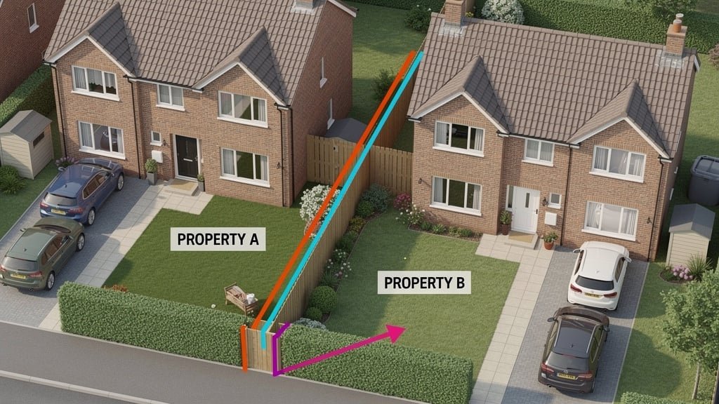
Understanding Property Boundaries in the UK
Property boundaries define where one person's land ends and another's begins. In the UK, these boundaries have legal significance but are often surprisingly imprecise. Unlike some countries where every property line is surveyed and registered precisely, UK property ownership relies on general boundary principles.
The General Boundary Principle
The Land Registry operates on a "general boundary" system. This means title plans show approximate boundary positions—typically within a few meters of accuracy. The red line on your title plan indicates the general extent of property or land but isn't guaranteed to be perfectly positioned. For most properties, this imprecision causes no problems, but when disputes arise, more accurate definitions become essential.
A professional boundary survey provides the precision that Land Registry plans lack. Our land surveyor team measures physical features, examines legal documentation, reviews historical evidence, and applies surveying standards to determine exactly where boundaries should be. The survey report provides detailed accurate measurements that can definitively resolve most boundary questions.
Types of Boundary Features
Boundaries can be defined by various physical features:
- Walls and Fences - Solid structures built along boundaries, though determining who owns them and whether they accurately follow the legal boundary requires investigation
- Hedges - Traditional boundary markers, though they can grow, move, or be replanted over time, creating uncertainty
- Natural Features - Rivers, streams, tree lines, or topographic features that historically defined property lines
- Buried Markers - Stones, posts, or other markers placed during original land division, often now hidden or destroyed
- Structures - Buildings, walls, or other man-made features that reference original boundaries
Part of carrying out boundary surveys involves identifying relevant features, determining their age and purpose, and assessing whether they accurately represent legal boundaries or merely subsequent additions or changes.
Common Causes of Boundary Disputes
Understanding why disputes arise helps prevent them. Here are the most common triggers our survey company encounters:
Fence Replacement or Installation
Many disputes begin when someone replaces an old fence or builds a new one. The new fence might be positioned differently than the original, or neighbors might disagree about responsibility for maintenance. Without a boundary survey establishing correct positions, discussions can quickly become confrontational.
One property owner we worked with in Manchester faced exactly this situation. Their neighbor erected a fence three meters into what they believed was their garden. Rather than escalating the conflict, they commissioned a boundary survey. The survey report showed the neighbor had indeed encroached significantly. With our professional survey data, they resolved the matter amicably—the fence was moved and good relationships maintained.
Building Extensions or Developments
Construction projects near boundaries often trigger disputes, especially if buildings or structures appear to cross property lines. Before any construction project near boundaries, getting a boundary survey prevents future problems. Knowing exact positions lets you build confidently while respecting neighbors' property rights.
Tree and Hedge Overgrowth
Trees and hedges growing on or near boundaries create practical and legal issues. Who owns the tree? Can branches be trimmed? What about roots damaging foundations? A boundary survey clarifies ownership, informing decisions about vegetation management and responsibility.
Property Purchase Queries
Property buyers sometimes discover boundary uncertainties during conveyancing. Perhaps the property description doesn't match what's on the ground. Maybe neighboring owners claim different boundary positions. A pre-purchase boundary survey provides peace of mind that you know exactly what land you're buying.
Access and Right of Way
Disputes about access routes, shared driveways, or right of way often involve boundary questions. Where does the access route actually run? Who owns the land it crosses? Boundary surveys combined with examination of title documents clarify these rights and responsibilities.
The Boundary Survey Process
When you need a boundary survey to resolve disputes or clarify property extent, understanding the process helps you prepare and know what to expect:
Stage 1: Initial Consultation and Research
Get in touch with Topo Surveyor to discuss your boundary questions. We'll ask about the property, the nature of any dispute, what you hope to achieve, and any relevant documentation you possess. This consultation lets us tailor the survey to your specific needs.
Before arriving on site, our land surveyor conducts extensive research:
- Land Registry Documents - We obtain and study current title plans and deed documents
- Historical Title Plans - Previous title plans sometimes show details lost on current versions
- Ordnance Survey Maps - Historical and current Ordnance Survey data provides context
- Planning Records - Planning applications and building regulation submissions might reference boundaries
- Conveyance Documents - Old deeds sometimes contain detailed boundary descriptions
- Aerial Photography - Historical aerial photographs show boundary features at different times
This research phase is crucial. Often, boundary questions can be answered partially or completely through documentary evidence before physical surveying begins. Getting correct information early saves time and keeps the survey cost reasonable.
Stage 2: Site Investigation
Our surveyor will conduct detailed site visits using highly specialised survey equipment to take accurate measurements of all relevant features:
- Physical boundary features (walls, fences, hedges, posts)
- Adjacent structures and buildings
- Natural features that might define boundaries
- Any buried or obscured markers
- Topographic features relevant to boundary definition
We use total station equipment and GPS technology to measure positions to centimeter accuracy. All measurements are referenced to Ordnance Survey coordinates, providing unambiguous positioning that any subsequent surveyor can verify.
We also interview property owners if available, asking about boundary history, any agreements with neighbors, and their understanding of where boundaries run. This context helps interpret physical and documentary evidence.
Stage 3: Analysis and Determination
The critical phase involves analyzing all evidence to determine boundary positions. Our land surveyor examines:
- Documentary Evidence Weight - How reliable and precise are title documents?
- Physical Feature Age - Which features are original boundaries versus later additions?
- Consistency Between Evidence - Do documents and physical features align?
- Adverse Possession Implications - Has long-term occupation affected boundary positions?
- Professional Judgement - Based on experience with similar properties and regional practices
Where evidence is ambiguous or conflicting—which is common in boundary surveys—we apply professional judgment based on surveying principles, legal precedents, and the weight of available evidence. Our survey report clearly explains our reasoning.
Stage 4: Survey Report Delivery
The boundary survey report includes:
- Scaled Survey Drawing - CAD drawing showing measured features, determined boundary positions, and Ordnance Survey coordinates
- Written Report - Detailed explanation of evidence examined, analysis performed, and conclusions reached
- Documentary Summary - Overview of title documents, historical records, and other evidence
- Photographic Evidence - Site photographs showing current boundary features
- Professional Opinion - Our expert opinion on boundary positions with confidence levels
- Recommendations - Suggested actions for resolving disputes or clarifying boundaries
The results of the survey provide the foundation for resolving disputes, whether through neighborly discussion, mediation, Land Registry applications, or court proceedings if necessary.
Using Boundary Surveys to Resolve Disputes
A professional boundary survey gives you the evidence needed to resolve conflicts effectively:
Neighborly Resolution
Most disputes resolve amicably once objective evidence clarifies the situation. Our survey report provides neutral, professional findings that often convince disputing parties. When both sides see clear evidence from an accredited land surveyor, emotion can be set aside in favor of factual resolution.
We've seen countless cases where neighbors were arguing based on assumptions or partial information. Once the survey report shows definitive boundaries, they work together to adjust fences, agree compensation for encroachments, or formalize arrangements that work for both parties.
Mediation Support
If neighborly discussion doesn't resolve matters, mediation offers a less confrontational path than court. Mediators need factual information to facilitate agreements, and boundary surveys provide exactly that. The survey report gives mediators and disputing parties the common ground needed for productive discussion.
Land Registry Applications
For certain boundary situations, you can apply to Land Registry for a "determined boundary." This upgrades the general boundary shown on title plans to a precise, legally defined line. Determined boundary applications require a detailed boundary survey by a qualified land surveyor—exactly what our survey company provides.
While determined boundaries aren't necessary for most properties, they're valuable when precision matters: boundaries following complex curves, boundaries critical to building positions, or boundaries where future disputes must be prevented definitively.
Legal Proceedings
Sometimes disputes escalate to court. Our surveyors have provided expert witness testimony in boundary cases, and our survey reports have been accepted as evidence in county and high courts. The thoroughness of our research, accuracy of our measurements, and professionalism of our reports satisfy court requirements.
Courts heavily weight professional survey evidence. When expert surveyors provide clear, well-documented opinions on boundary positions, judges typically follow those conclusions unless contradictory evidence emerges.
Preventing Boundary Disputes
While boundary surveys resolve existing disputes, they're even more valuable for prevention:
Before Property Purchase
Commissioning a boundary survey before completing a property purchase identifies potential issues early. You'll know exactly what land you're buying, whether boundaries are where you expect, and if any encroachments or anomalies exist. This information lets you negotiate price adjustments, request rectification, or simply make informed decisions.
Before Construction Projects
Before building near boundaries, a survey clarifies where you can safely build without encroaching. This prevents the nightmare of discovering mid-construction that your extension crosses neighbor's land. The survey cost is tiny compared to the expense of demolishing and rebuilding structures placed incorrectly.
When Replacing Boundary Features
If you're replacing an old fence, hedge, or wall, a boundary survey ensures the new feature follows the correct line. Even if the existing feature has been there for decades, it might not accurately represent the legal boundary. Better to confirm positions before building than discover problems later.
Periodically for Peace of Mind
Some property owners commission boundary surveys simply for peace of mind—knowing exactly what they own, having professional documentation of boundaries, and possessing evidence that prevents future disputes. This proactive approach provides security and clarity about property rights.
Cost Considerations
Boundary survey costs typically range from £500 to £2,000 depending on:
- Site Size - Larger properties require more measurement work
- Boundary Complexity - Complex boundary lines or multiple disputed sections increase costs
- Research Required - Extensive documentary research adds time
- Access Issues - Difficult site access or adjacent properties increase fieldwork time
- Evidence Complexity - Conflicting evidence requiring detailed analysis affects costs
While survey costs represent an investment, compare this to alternatives: legal fees for court action run into thousands or tens of thousands. Property value loss from unresolved disputes can be substantial. Stress and damaged neighbor relations have costs beyond money. A boundary survey resolves matters efficiently and cost-effectively.
Choosing a Surveyor for Boundary Work
Not all surveyors have equal expertise in boundary determination. When you need a survey for dispute resolution or boundary clarification, consider:
Qualifications and Experience
Look for surveyors with specific boundary survey experience. Our topographical surveyors are accredited under CIOB, RICS, and RPSA, with extensive experience in boundary determination. We've handled hundreds of boundary cases from simple clarifications to complex multi-party disputes.
Research Capabilities
Boundary surveys require more than fieldwork—thorough documentary research is essential. Ensure your survey company has access to Land Registry documents, historical records, and research resources needed for comprehensive investigation.
Report Quality
The survey report must be clear, detailed, and defensible. Ask to see example reports. They should explain methodology, present evidence transparently, and support conclusions with sound reasoning. If reports seem superficial or lack detail, look elsewhere.
Communication Skills
Boundary surveys often involve explaining technical matters to non-surveyors: neighbors, solicitors, mediators, or courts. Choose surveyors who communicate clearly, answer questions patiently, and present findings accessibly.
Conclusion: Clarity Through Professional Surveying
Property boundary disputes are stressful, but they don't have to be destructive or expensive. Professional boundary surveys provide the objective evidence needed to resolve conflicts efficiently while maintaining relationships and protecting property rights.
At Topo Surveyor, we approach every boundary survey with professionalism, thoroughness, and understanding of the human element behind property disputes. Our land surveyor team combines technical expertise with communication skills to help property owners resolve boundary questions confidently.
If you're facing boundary uncertainty, considering a property purchase, planning construction near boundaries, or dealing with a dispute, get in touch with our survey experts. We'll discuss your situation, explain how a boundary survey can help, and provide a transparent quote for professional services that deliver clarity and peace of mind.
Need a Boundary Survey?
Our accredited surveyors provide professional boundary surveys across the UK, resolving disputes and clarifying property rights with accurate measurements and thorough research.
Need a Professional Boundary Survey?
Our accredited surveyors provide accurate boundary surveys that definitively resolve property disputes and protect your land rights. We use precise measurement equipment and reference official records to establish exact property boundaries.