Modern land surveying has been transformed by technological innovation. Where surveyors once relied primarily on measuring tapes and optical theodolites, today's professionals use highly specialised survey equipment that captures millions of measurements with centimeter precision in minutes. Topo Surveyor invests continuously in the latest survey technology, ensuring our land surveyor team delivers the accuracy, efficiency, and comprehensive data that contemporary projects demand.
This guide explores the advanced equipment that enables professional topographical surveys, measured building surveys, utility surveys, and boundary surveys. Understanding these technologies helps clients appreciate the value professional survey services deliver and the capabilities that differentiate quality survey providers from those using outdated methods.
Total Station Instruments: The Surveying Workhorse
Total stations represent the evolution of traditional theodolites, combining electronic angle measurement, laser distance measurement, and on-board data processing into integrated instruments that form the backbone of modern surveying. These sophisticated devices remain essential tools despite newer technologies, offering versatility, accuracy, and reliability across diverse survey applications.
Modern total stations measure horizontal and vertical angles electronically to sub-second precision—typically one to five arc seconds depending on instrument grade. This angular accuracy translates to millimeter positioning precision at typical survey distances. Simultaneously, the instruments emit laser pulses to prism targets or reflectorless to surfaces, measuring distances to several millimeters accuracy at ranges up to one thousand meters with prisms or several hundred meters reflectorless. This combination of angle and distance measurement determines three-dimensional positions of any point the surveyor sights.
Robotic total stations add automation that dramatically increases surveying efficiency. The surveyor carries a prism pole with radio control rather than remaining at the instrument. The total station tracks the prism automatically, allowing the surveyor to position the prism on features requiring measurement while triggering measurements remotely. This single-person operation eliminates the need for assistants traditionally required for manual total station work, cutting labor costs while improving survey speed. Our land surveyor team uses robotic total stations extensively for topographic land surveys where hundreds or thousands of points need capturing.
On-board software transforms total stations from mere measuring devices into field computers. Surveyors can download site plans, stake out design coordinates, calculate areas and volumes, run traverse calculations, and export data in multiple formats—all performed in real-time during fieldwork. This computational capability reduces office processing time and enables surveyors to verify data quality while still on site, catching errors when correction remains simple rather than discovering problems after leaving.
Total stations excel for establishing control networks that other survey methods reference. The instruments set primary control points with high accuracy, creating frameworks that GPS measurements, laser scanning data, and other survey information tie into. This control establishment remains crucial for maintaining survey accuracy and ensuring different datasets integrate properly. Even projects using primarily alternative technologies typically begin with total station control surveys providing the accurate foundation everything else builds upon.
Global Navigation Satellite Systems
GPS technology—more accurately termed GNSS (Global Navigation Satellite Systems) since it includes American GPS, Russian GLONASS, European Galileo, and Chinese BeiDou satellites—has revolutionized large-area surveying. GNSS receivers determine positions by measuring distances to multiple satellites, achieving remarkable accuracy when used with professional techniques.
Real-Time Kinematic surveying represents the most accurate GNSS mode used in professional surveying. RTK requires two receivers—a base station on a known point and a rover the surveyor carries to points being measured. The base station transmits correction data to the rover via radio or mobile phone networks, allowing the rover to calculate positions with centimeter accuracy in real-time. This accuracy rivals traditional total station surveying while offering faster measurement rates and working at much longer distances from control points.
Network RTK services eliminate the need for surveyors to establish base stations themselves. Commercial network operators maintain permanent reference stations across the UK transmitting correction data via mobile internet connections. Surveyors subscribe to these services and receive corrections directly to their rover receivers. This convenience means survey crews can arrive at unfamiliar sites and begin RTK surveying immediately without time-consuming base station setup.
GNSS surveying proves particularly valuable for large-scale topographical surveys, infrastructure mapping, and establishing widely-spaced control points. The technology works efficiently in open environments where satellite visibility is good. However, GNSS struggles where satellite signals are obstructed—in forests, urban canyons with tall buildings, or under bridges and structures. Our surveyors assess site conditions and select appropriate technologies, using GNSS where it excels and switching to total stations where satellite coverage proves inadequate.
Post-processed kinematic surveying achieves even higher accuracy than RTK by recording satellite data for later processing using precise orbital information downloaded after satellite passes. PPK proves useful when real-time corrections are unavailable or when maximum accuracy is required. Processing adds time compared to RTK's immediate results, but the accuracy gains justify processing delays for demanding applications.
3D Laser Scanning Technology
Three-dimensional laser scanners represent the most data-rich survey technology, capturing millions of measurement points per second to create detailed point clouds representing scanned objects or spaces. This comprehensive data capture has transformed measured building surveys, heritage documentation, and complex industrial facility mapping.
Terrestrial laser scanners work by emitting laser pulses and measuring return times to calculate distances. The scanner head rotates, systematically scanning in all directions to capture everything visible from the scanner position. A typical scan session lasting several minutes captures fifty to one hundred million points, each with precise three-dimensional coordinates. Multiple scans from different positions are registered together, creating complete site coverage with no blind spots.
The resulting point cloud data provides exceptional detail. Every surface feature—cracks in walls, bolt heads on structural steel, decorative moldings on heritage buildings—appears in the point cloud if visible during scanning. This comprehensive capture means surveyors need not decide in advance which details to measure; everything is recorded, allowing information extraction later as requirements emerge. For heritage buildings or complex facilities where comprehensive documentation provides long-term value beyond immediate project needs, laser scanning creates archival records preserving building geometry as it existed at survey time.
Point cloud processing converts raw scan data into usable survey deliverables. Specialized software registers multiple scans together using overlapping features or targets placed in scan areas. The consolidated point cloud is cleaned to remove extraneous elements like people or equipment captured during scanning. Finally, CAD drawings are created from point cloud data, tracing building outlines, extracting dimensions, and creating the plans, elevations, and sections that architects and engineers need for design work.
Laser scanning excels for complex buildings where traditional surveying would be extremely time-consuming. Victorian factories with exposed structural steel and complex roof trusses, historic buildings with intricate architectural details, industrial facilities with dense pipework and equipment—these challenging subjects scan efficiently while producing comprehensive documentation that hand measurement could never match economically.
Mobile laser scanning extends three-dimensional capture to linear infrastructure and street environments. Scanner systems mount on vehicles or backpack rigs, continuously capturing while moving. This mobility enables rapid surveying of roads, railways, corridors, and streetscapes. The technology proves valuable for infrastructure asset management, highway design, and large-area urban mapping where stationary scanning would require impractical numbers of scanner setups.
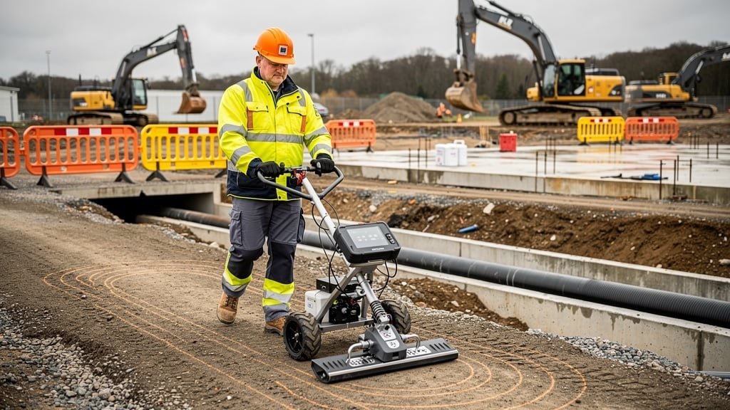
Ground-Penetrating Radar Systems
Ground-penetrating radar addresses the challenge that most survey technologies face—they only capture visible surfaces. GPR uses radio waves to image underground features, making it essential for utility surveys detecting buried pipes, cables, and other subsurface objects that represent major risks for excavation projects.
GPR systems consist of antennas that emit radio pulses into the ground and receive reflections from buried objects or ground layer interfaces. Different materials reflect radio waves differently—metal pipes give strong reflections, plastic pipes weaker but still detectable returns, soil layers with varying moisture or density show as distinct horizons. By measuring reflection timing, GPR determines depths to detected objects. By pulling antennas across sites in systematic grids, surveyors build images showing underground feature patterns.
Antenna frequency selection affects detection capability and resolution. Higher frequency antennas provide better resolution imaging shallow features clearly but penetrate only one to two meters. Lower frequency antennas penetrate deeper—potentially three to five meters—but with reduced resolution making small object detection difficult. Our surveyors select antenna frequencies appropriate for expected utility depths and required detail levels.
Ground conditions significantly affect GPR performance. Dry sandy or gravelly soils provide excellent results with deep penetration and clear imaging. Wet or clay soils reduce penetration and image quality. Very wet conditions might limit useful depth to less than one meter. Surveyors assess site conditions and adjust survey strategies accordingly, perhaps combining GPR with electromagnetic utility location methods for comprehensive underground service detection.
GPR excels for non-metallic utility detection where electromagnetic locators prove ineffective. Plastic water pipes, concrete pipes, and fiber optic cables respond poorly to electromagnetic methods but give clear GPR reflections. This capability makes GPR essential for comprehensive utility surveys where service types are unknown or where plastic pipes are suspected.
Data interpretation requires experience and expertise. Raw GPR data appears as complex images that untrained viewers find difficult to interpret. Experienced operators recognize patterns indicating pipes, cables, voids, or other features. They distinguish utility signatures from natural ground variations, tree roots, or buried rubble. This interpretive skill determines survey quality—the same equipment operated by inexperienced users produces ambiguous results while expert operators extract clear utility positions.
Electromagnetic Utility Location Equipment
Electromagnetic locators represent the primary tool for underground utility surveys, detecting and tracing buried metallic pipes and cables. These devices have advanced significantly from simple metal detectors to sophisticated systems that identify utility types, measure depths, and trace routes precisely.
Active location applies electrical signals to utilities through access points—cable manholes, valve chambers, or pipe connections. The surveyor connects a signal transmitter to the utility then uses a receiver to trace the signal along the utility route. This active method provides highly accurate location for specific utilities where access exists, allowing surveyors to distinguish target utilities from other nearby services.
Passive location detects signals that utilities naturally emit or carry. Power cables carry alternating current that generates detectable electromagnetic fields. Radio frequency signals flow on telecommunications cables. Some utilities carry stray electrical currents from various sources. Passive detection doesn't require utility access but provides less certainty about which specific utility is detected.
Modern electromagnetic locators include features that improve detection capability and accuracy. Signal strength indication helps surveyors determine when they're directly above utilities versus detecting side-lobed signals from offset positions. Depth measurement calculates utility burial depth from signal characteristics, though accuracy varies with conditions. Some systems identify signal frequencies, helping distinguish power cables from telecommunications or multiple utilities running parallel.
Limitations exist that operators must understand. Electromagnetic location only works for metallic utilities or those in metallic conduits. Plastic water pipes, fiber optic cables, and concrete pipes require alternative detection methods like GPR. Signal interference from underground metal debris, nearby power sources, or multiple parallel utilities can complicate detection. Conductive soils might carry signals away from utilities making location imprecise.
Professional utility surveys use multiple detection methods to achieve comprehensive results. Electromagnetic location traces metallic utilities efficiently. GPR detects non-metallic services. Acoustic methods find active water pipes. Combining techniques provides confidence that all significant utilities have been located rather than relying on any single method that might miss service types outside its capabilities.
Digital Levels and Modern Height Measurement
Precise height measurement remains fundamental to surveying despite technological advances in positioning methods. Digital levels represent the evolution of traditional optical levels, adding electronic reading and data recording to speed operations and improve accuracy.
Digital levels read special barcoded staffs electronically rather than relying on surveyors reading graduations optically. The level images the barcode pattern, processes the image to determine staff reading, and records measurements automatically. This electronic reading eliminates human reading errors that affected traditional optical leveling, improving accuracy while dramatically speeding operations. A skilled surveyor with digital level can complete leveling work two to three times faster than with optical equipment.
Accuracy of professional digital levels reaches sub-millimeter standard deviations per kilometer of leveling—approaching the precision of first-order geodetic leveling that establishes national height networks. This accuracy proves essential for engineering projects where precise height control matters—bridge construction, railway projects, or building foundations where millimeter height errors can cause structural problems.
Data logging capabilities mean digital levels record measurements directly to memory rather than requiring manual entry in field books. Data transfers to computers for processing, eliminating transcription errors that plagued traditional workflows. Processing software automatically checks for closing errors, calculates adjusted heights, and produces reports. This automation reduces processing time and improves reliability.
Traditional optical levels remain relevant for situations where simplicity and reliability outweigh speed advantages. They work without batteries in any lighting conditions and provide backup capabilities when electronics fail. However, for production surveying where speed and accuracy both matter, digital levels have largely replaced optical instruments in professional survey practice.
Integration of Multiple Technologies
Modern topographical surveys rarely rely on single technologies. Professional land surveying services integrate multiple technologies, selecting appropriate tools for different aspects of projects and combining data to deliver comprehensive survey reports.
A typical topographic land survey might begin with GPS establishing site control points referenced to Ordnance Survey coordinates. Total stations then survey detailed topography around buildings or in areas with poor satellite visibility. Laser scanning captures complex building facades. Electromagnetic and GPR surveys detect underground utilities. Digital levels measure precise bench mark heights. Each technology contributes measurements within its areas of strength, and all data integrates into unified CAD drawings showing complete site information.
This multi-technology approach delivers accuracy, efficiency, and completeness that no single method achieves alone. GPS works brilliantly for open areas but fails indoors or under tree canopy—total stations cover these areas seamlessly. Laser scanning documents complex geometry comprehensively but struggles with moving objects or highly reflective surfaces—traditional surveying supplements scan data in these situations. GPR detects non-metallic utilities that electromagnetic methods miss. Combining technologies eliminates gaps while exploiting each method's advantages.
Professional judgment determines appropriate technology selection. Our land surveyor team assesses site conditions, project requirements, and budget constraints when planning surveys. Sometimes simple methods suffice; other times multiple advanced technologies prove necessary. Experience guides these decisions, ensuring clients receive appropriate survey approaches delivering required information efficiently.
Technology Investment and Expertise
Highly specialised survey equipment represents significant capital investment. Professional-grade total stations cost ten to thirty thousand pounds. Laser scanners range from fifty to one hundred and fifty thousand pounds. GPS systems, utility detection equipment, and digital levels add tens of thousands more. This equipment investment distinguishes professional survey companies from providers using consumer-grade tools that lack accuracy, reliability, or capability for demanding projects.
However, equipment alone doesn't ensure quality surveys. Operating survey technology effectively requires training, experience, and continuing professional development. Surveyors must understand equipment capabilities and limitations, recognize when measurements appear questionable, adapt to challenging site conditions, and integrate data from multiple sources properly. This expertise develops through years of practice and represents the true value professional land surveying services deliver.
Our survey company maintains modern equipment and invests continuously in surveyor training. We update technology as innovations emerge, ensuring clients benefit from latest capabilities improving accuracy, efficiency, or deliverable quality. When you commission topographical surveys from Topo Surveyor, the survey data you receive reflects both state-of-the-art equipment and the experienced surveyors who operate it skillfully.
Conclusion: Technology Enabling Better Surveys
Advanced survey equipment has transformed land surveying from labor-intensive manual measurement to technology-enabled data capture delivering unprecedented accuracy, speed, and comprehensiveness. Understanding the technologies that modern surveyors use helps appreciate the value professional surveys provide and the capabilities that quality survey data enables for design, planning, and construction.
At Topo Surveyor, we combine highly specialised survey equipment with experienced survey professionals who understand how to deploy technology effectively. Our multi-technology approach delivers comprehensive survey reports supporting successful projects.
If your project requires professional land surveying services, get in touch with our survey experts. We'll discuss your requirements and deliver survey data captured using appropriate technologies for your specific needs.
Professional Survey Technology and Expertise
Our surveyors use the latest survey equipment including total stations, GPS, laser scanners, and ground-penetrating radar to deliver accurate, comprehensive survey data for your project.
Experience Cutting-Edge Survey Technology
Our surveyors use the latest highly specialised equipment including GPS, laser scanners, and total stations to deliver accurate survey data for your projects. Advanced technology means better results.